Three landmasses in a four-cornered sea — charted complete. What grows now is the telling.
The living map
The whole chart in one window: pan, zoom, and click a plate's territory to fly to it, see the plate as inked, and read its survey notes. Every territory is drawn where its plate was actually surveyed — all of them cut from the one heightmap.
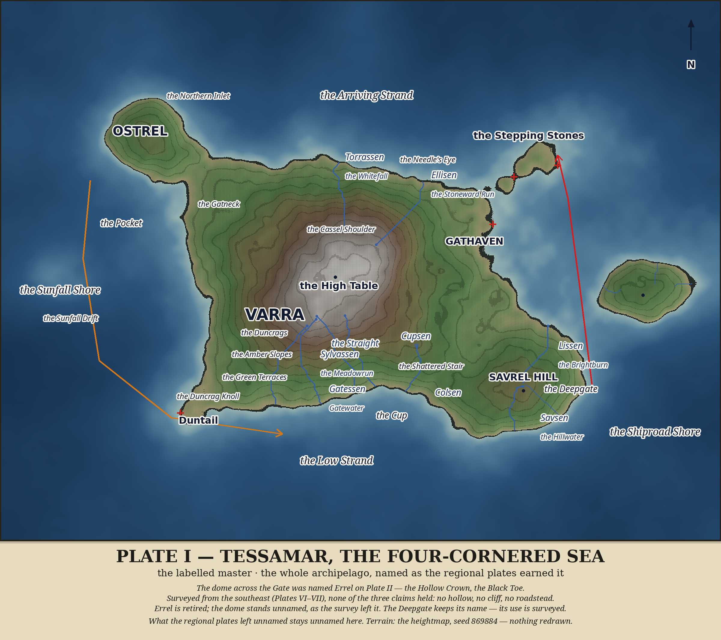
The whole of Tessamar on one chart — Varra and her coasts and rivers, the Gate and the Stones — and across the eastern water, a dome that wears no name.
The world as it stands
The world is called Tessamar — the Four-Cornered Sea — named for the shape of its great island, which any sailor coasting it will tell you has four sides, like a table set down in the water. Three landmasses stand in it: Varra, the great isle; the Stepping Stones, barely land at all, at the Gate's northern narrows; and one round island in the east that wears no name. Beyond the chart on every side lies the Unwritten — water not yet sailed, land not yet drawn. It is not empty. It is only unwritten.
Varra rises in rings from every shore: the Strand at the water's edge, then the Green Terraces, the Amber Slopes, the brown Duncrags, and at the exact heart of the world the High Table — a broad, gentle crown of pale high ground, flat-topped, the first thing seen from any deck approaching from any direction. The one true thing known about Tessamar is this: at its centre stands a mountain that is flat on top, and everything else in the world is downhill from it.
The Table gives water to the four quarters of Varra and keeps none for itself — rain that falls on the pale flat finds no soil to hold it and runs off at the edges — and so the rivers are born at its rim. In the north, Torrassen, the Whitefall, runs straight and swift down the great northern gully. In the northeast, Ellisen, the Stoneward Run, bows wide around the pale Cassel Shoulder rather than cut its elder stone. In the southwest, Sylvassen, the Meadowrun, walks a wide, respectful circle around the dark Duncrag Knoll. And in the south the rim is generous past all pattern: three great rivers — Gatessen, called Gatewater, the Straight, and Cupsen — rise within a few cells of one another and fan to three separate mouths, with lesser waters besides. A dozen smaller burns run to the sea besides the named rivers, and most of them wear no names at all.
Varra's four coasts each carry two names, an old one and a sailor's. The north coast is the Cassen Coast, the Arriving Strand — pale screes under a pale mountain, the first land seen by any ship out of the northern Unwritten. The east is the Gatmar Coast, the Shiproad Shore, facing the Deepgate, where every ship that matters passes within sight. The south is the Sylvamar Coast, the Low Strand — low, green, and gentle. The west is the Dunmar Coast, the Sunfall Shore, where the day ends over the Unwritten. In the northwest, the round hill-isle Ostrel hangs off Varra's corner by a narrow green neck; in the southeast stands Savrel Hill, the south's own height, a younger, greener dome that makes a river of its own.
And the High Table is empty. No ruin, no temple, no field, no smoke stands on the pale flat heart of the world — walked around, never crossed. Three stories are told about it, and none of them is believed: that it is a table set for gods who never came to dinner; that it was the first field, farmed until the soil gave out and the farmers walked down to the Green Terraces and never looked back; that it is where the world was cut flat so everything else could be downhill. Who lives in Tessamar, if anyone, the charts do not say.
Names in Tessamar are given only where the land has earned one — names are for use, not inventory. What stays unnamed stays unnamed on purpose.
How to read these charts
A red cross marks ground where the water and the land argue and neither wins — awash in all but name, a wading crossing, not a walk. A dotted outline marks a crown or a rim that can be traced but not walked. A filled dot is a river's head; an open circle is a head born on a slope, not a rim. An arrow is water moving, not land. What is left blank is left blank on purpose.
The little language in the names
The old names grow from a few roots: mar, the sea; -el, a small land, an isle; Varra, the great land, the first land; -sen, a river, from the old word for “thread”; torr-, swift and white-watered; ell-, slow and wandering; cass-, pale, grey-white; dun-, dark, and dusk, and the west; sylv-, green and growing; gat-, a gate, a strait-road. Sailors' names in the common tongue sit beside the old names, the way they do in any real atlas.
The plates
Plate I — The Foundation. The whole world at a glance: one great isle, one small doorstep of stones, one unnamed dome.Plate II — The Deepgate. The world's first road, running on tide between two shores.Plate III — The Western Neck and Ostrel. The quiet side of the world, where the water walks.Plate IV — The South. Three rivers off one rim, and a bay that turns like a slow mill.Plate V — The High Table. The centre of the world, and its emptiness.Plate VI — Savrel, the Southeast. One hill, two rivers, and a shore that is a curve and a silence.Plate VII — The Northeast Island. A dome in open water that no name has ever taken.Plate VIII — The Stepping Stones. The Gate's north door: two islets and a wading.
Plate I — The Foundation
The whole world on one chart
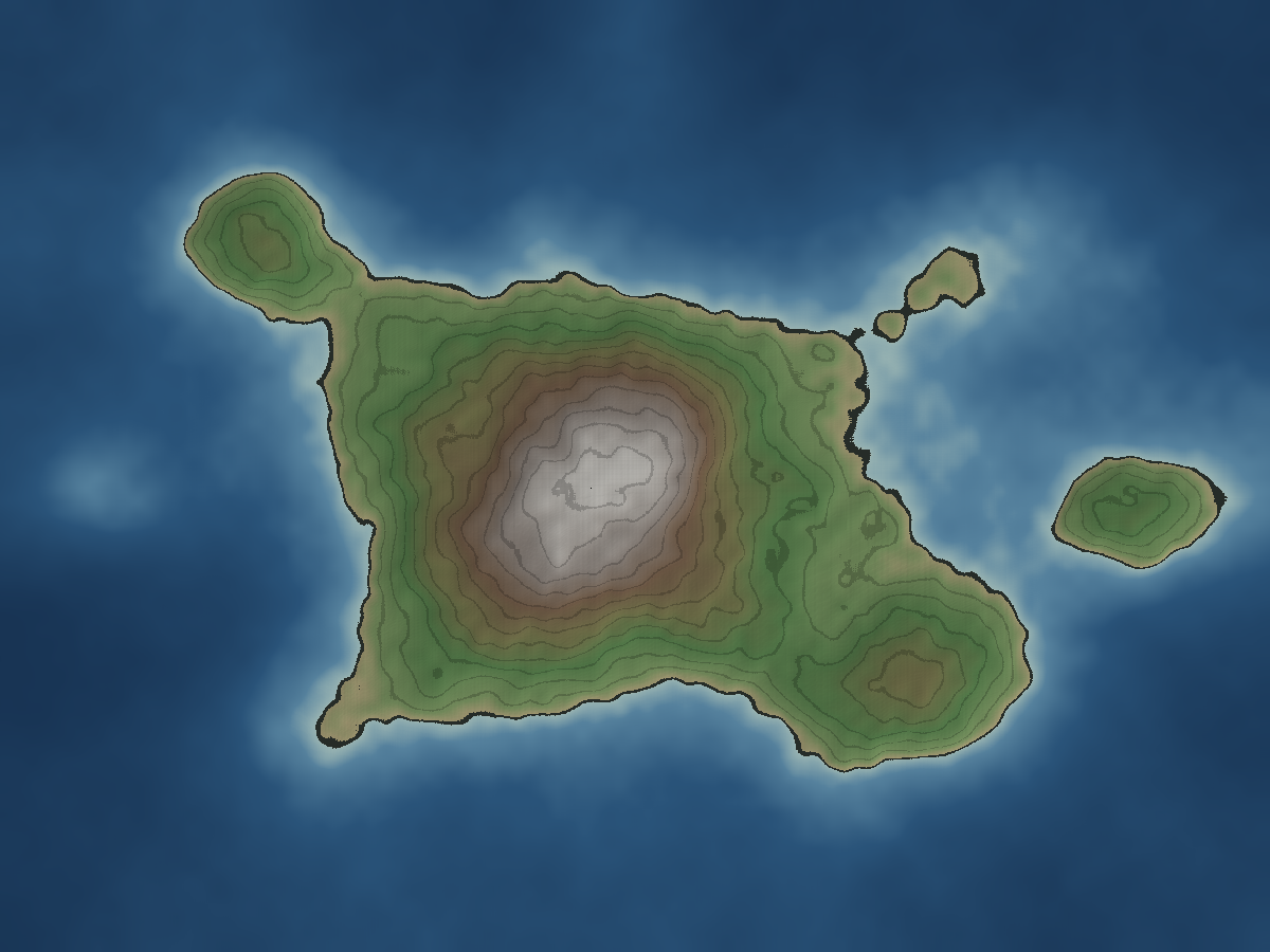
From high above, Tessamar is three pieces of land in a four-cornered sea. Varra fills the middle of the chart — four-sided, terraced, her rings stepping down from the pale crown at her heart to four named coasts. Off her northwest corner hangs Ostrel, joined to her by a thread of green. Southeast of her heart, Savrel Hill rises out of her own flank, the second height of the world. East of Varra, deep water — the Deepgate — and beyond it a single round island, alone in its shallows. Northeast, where the Gate narrows, the Stepping Stones stand in the fast water. Everything else on the chart is the Unwritten.
The foundation chart is drawn without labels, and that is honest to what it shows: before any name is spoken, the world is shape and height and water. The names live on the closer plates, where the land has been walked closely enough to earn them.
Plate II — The Deepgate
The tide road
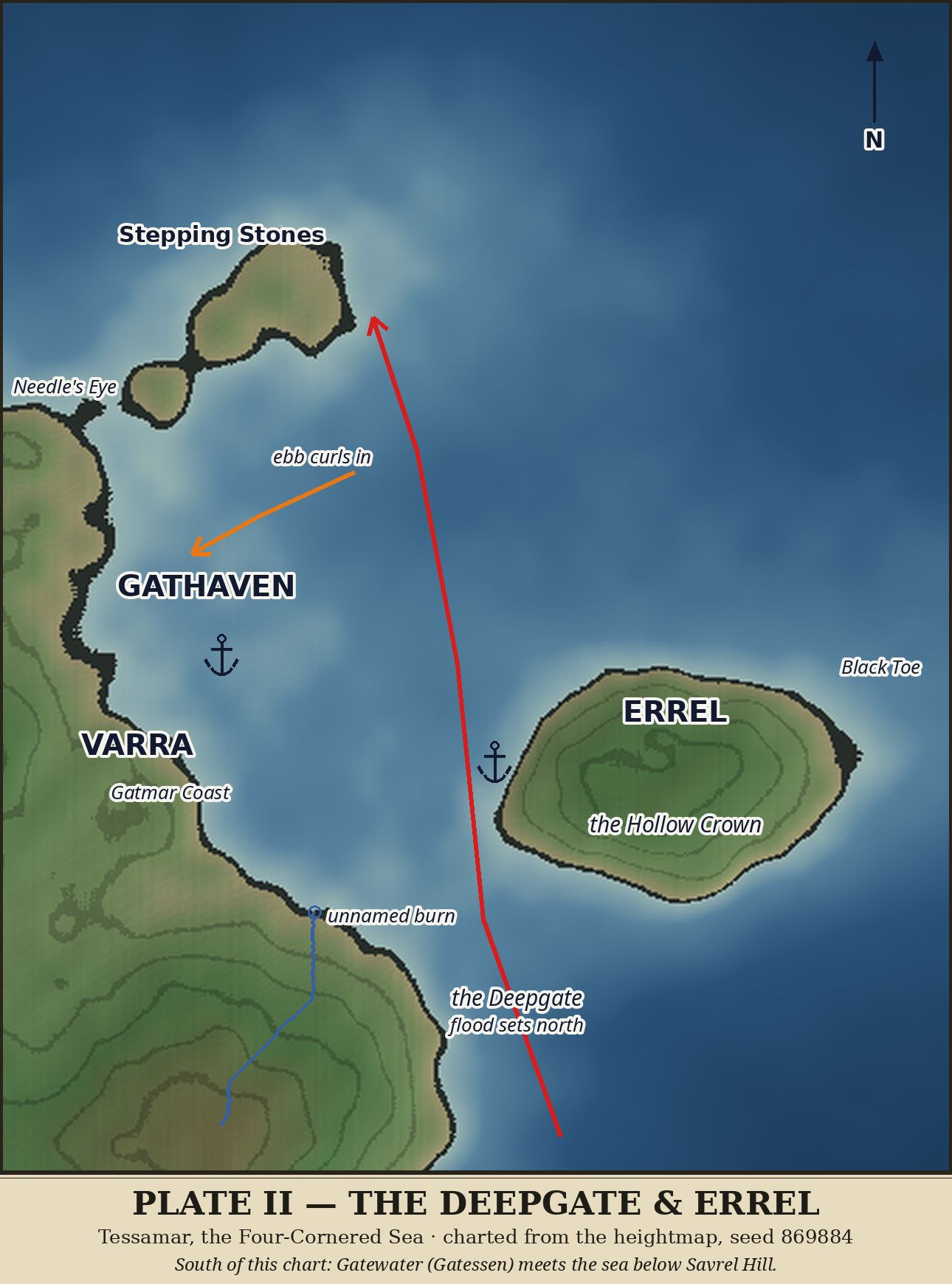
The Deepgate is the world's first road, and it runs on tide. The flood sets north through the channel, bending toward the eastern shore as it goes, and runs fastest where the water is squeezed at the northern narrows by the Stepping Stones — a ship riding the flood is carried up the strait like a leaf in a gutter. The ebb runs home south. The true channel, the darkest water, runs mid-strait; pale shallows fringe both coasts, so deep-draft ships keep to the channel and small boats can work in close along either shore.
On Varra's side, one real bay bites into the Shiproad Shore below the cape: Gathaven, the only sheltered water on this coast. On the ebb, the water sliding south past the bay's mouth curls into it — a slow back-eddy that turns the haven into a settling bowl. That is the whole secret of Gathaven: ride the flood north to do your business, come home on the ebb, and the bay catches you instead of spitting you past. Silt settles in the bowl too, so the bottom is soft and holds an anchor well — and must be sounded, never trusted. The two are the same fact, as most kindnesses are. If Tessamar ever grows a port, it grows here; the haven's fresh water comes down to the open shore just south of the bay — Lissen, the Brightburn, the brightest water on that coast. Northwest of the bay, Varra's cape ends in a small hooked point under the Stones — a lookout shape, if anything ever is.
Across the Gate, the eastern island rides like a moored ship: one ringed green dome standing in a shallow apron of its own, its summit a broad flat cap, its easternmost land low where the isle steps down into deep water. Its shore is smooth all round and offers no harbor — the Gate's east side is a coast to look at, not to land on. The island wears no name, and nothing about it asks for one. South of this country, below Savrel Hill, Gatewater meets the sea — that shore belongs to the southern plates.
Plate III — The Western Neck & Ostrel
Where the water walks
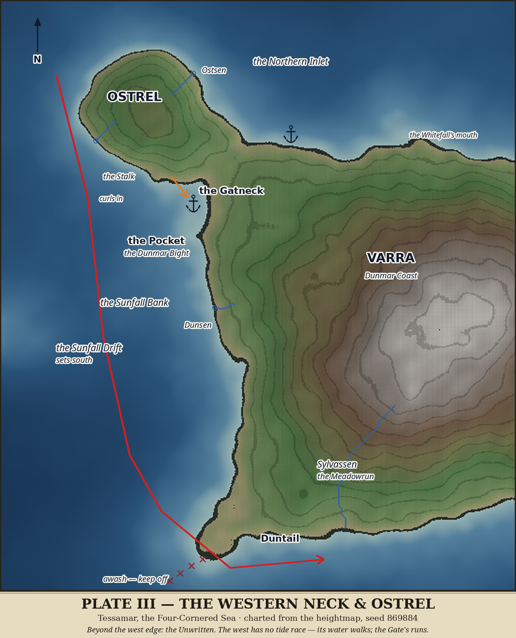
The west is the quiet side of the world, and it is honest about why. Everything on the Gate side runs — tide races, roads, harbors that catch. The west walks. Its water is a drift, its coast is a long straight shore with one small bite taken out of it, and its one island hangs on by a thread of green so low that the oldest saying about it — at high water it may be an island — turns out stranger than tides. This is the sunset side: the Dunmar Coast, the Sunfall Shore, where the day ends over the Unwritten.
Ostrel hangs off Varra's northwest corner like a thumb on a stalk, and the stalk has two names: the Gatneck in the old tongue — the land-gate between two waters — and the Stalk, which is simply what it looks like from any deck. The neck is a green sill standing a hair above the sea, and its waist pinches narrow, low Strand-and-Terrace ground where a walker is never far from seeing water on both sides. No honest tide climbs the saddle — it stands a fourteenth of the world's whole height above the water. Two explanations are told and neither is believed yet: that the saying is a fossil from a wetter age, when the sea stood higher and Ostrel was an island in fact; or that it garbles one great storm, when surge water sheeted across the waist for a night. Both stories agree on the important thing — the neck is a sometimes-place, and Ostrel's islandhood is a matter of when, not whether.
Ostrel itself is a modest, honest hill, Amber-Slope height, nothing like the Table and not pretending to be. It sits in a pale shallow apron of its own, and it carries two burns: Ostsen, its own thread, falling off the northeast face to the Northern Inlet; and a west burn that keeps only its sailor description, the Westburn, because some waters are too small for old names. The isle's top carries a shallow, off-centre dip — a worn hollow, a hill's tired top. It wears no name. Not everything in a world is a story; some of it is just a hill, settling.
The Northern Inlet is the north sea reaching down between Ostrel's northeast shore and the Arriving Strand, and it is a cul-de-sac — the neck sees to that; no water passes through. What enters the inlet settles, which makes its west end, under Ostrel's east shore, a true roadstead: pale water, the westerlies broken by the isle's hill, Varra's north coast in reach.
South of the neck, the Dunmar Coast takes its one bite: the Dunmar Bight, which sailors call the Pocket — the name the chart inks, because charts name anchorages by their use. The Pocket is the west's first harbor, and its secret is Gathaven's shape, gentler: the southward drift, passing the bight's mouth, sheds a slow back-eddy inward; the water turns lazily and settles, and the sand settles with it — soft bottom, fair holding for small craft, close under the neck's lee, sheltered from the north and northwest and open only to the southwest swell. South of the Pocket the shore runs long and nearly straight, terrace above terrace, and offers no second bite. Partway down it, the sea floor lifts over the Sunfall Bank — a broad, low swell, no shoal and no hazard, that any keel crosses without knowing; but the sounding line jumps in a leadsman's hand there, and if anything ever fishes this coast, it fishes there.
The west's water has a name and a direction: the Sunfall Drift, setting south. This is where the Deepgate's flood comes home — what goes north through the Gate must return, and the west is the return road: spreading west along the Arriving Strand, dividing at Ostrel, walking on down the whole length of the Sunfall Shore, and at the last bending east around the point toward the Gate again. There is no tide race here, because there is no strait to race through. A ship leaving the Pocket southbound rides the drift the way a leaf rides a slow stream, and the whole coast is a one-way road home.
One true burn belongs to this coast: Dunsen, the dusk-river, falling off the west Green Terraces due west to the strand — the only fresh water between the Pocket and the point. At the coast's end, Varra steps into the west sea on Duntail: a long, low, sandy point standing at the sea's own height exactly — dry at the chart's datum, awash in any weather, with a shallow tail trailing southwest underwater like a foot dragging. It is a spit, not a headland, and the chart marks its tail plainly: awash — keep off. Just east of its shallows, the Meadowrun comes down to the Low Strand, ending the west's country in green water.
Plate IV — The South
The generous side
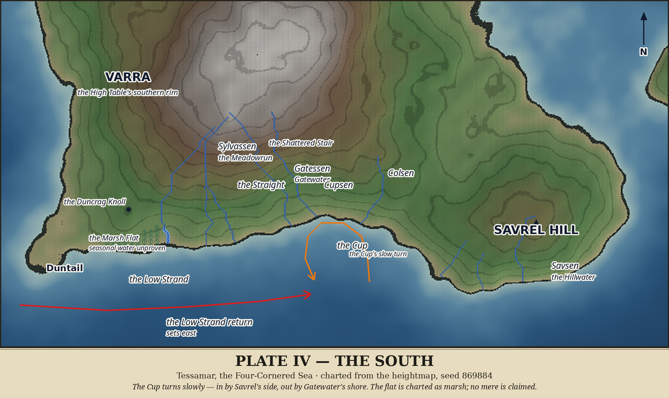
The south is the generous side of Varra. The west walks and the Gate runs, but the south gives — three great rivers off one rim, a bay that turns like a slow mill, a shore named for how low it lies.
The southern rim keeps its water the way a hand keeps fingers. Gatewater, the eldest, comes down through the Shattered Stair — and from above, the Stair is not a scar on the hill but a pattern in the water: the river changes direction turn by turn, stepping down through the fallen ground. The legend says the blocks are building stones dropped by the god who was making the Table flat — he fumbled them, and the river has been stepping around his mistake ever since. Whether the stones lie below the chart's sight, or the zigzag invented its own legend, is left open; a legend a river tells about itself is still a kind of truth about the river. Gatewater's mouth stands on the Cup's west shore.
Beside it, born a few cells from its sister's head on the same high rim, runs the Straight — Gatewater's twin, and nothing alike. Where Gatewater zigzags, the Straight does one thing for its whole course: due south, the longest and straightest run on the island, through the frayed broken shore to an open mouth on the Strand. Sailors also call it Gatewater's Sister. The broken shore it crosses — channels and sand flats east of the Meadowrun's mouth — keeps its question: tidal cuts, a river's own channels, or drowned ground, not yet known. The third prong, Cupsen, runs down the low valley to the head of the bay, filling it — the Cup's own thread. And the lesser waters: Colsen, the col river, born on the high slopes between the Table and Savrel and draining to the bay's east shore; and Savsen, the Hillwater, of which Savrel's plate tells. Three rivers, or one gate-system in three prongs that never join? They share nothing but a birthplace, and plenty of siblings share that — so they are told as three rivers of one rim.
East of Gatewater's mouth, the Strand takes its one bite: the Cup, the south's only bay — a round, held shape of water opening due south between Gatewater's shore and Savrel's western toe. The Cup does not sit still. Along the south coast runs the Low Strand return, the Sunfall Drift's eastward leg — the basin's water walking home — and dragging past the bay's mouth, it turns the Cup in a slow shear eddy: in by Savrel's side, across the head, out by Gatewater's shore. Three river mouths plume out through the turn, so the water flushes as it turns, and no settling bowl forms. The chart inks no anchor in the Cup: its soundings are ample, its holding unproven. A bay is not a harbor until the bottom has been asked, and nobody has asked yet.
West of the Meadowrun's spreading mouth, the lowland widens into the Marsh Flat — the flattest ground on the coast, nearly a thousand cells within a hand's breadth of the sea, sloping almost imperceptibly shoreward. Marsh, flood-plain, or seasonal mere, the closest looking cannot say, and no water has ever been seen standing on it — so the flat wears no proper name, and will get one on the day water is seen there, and not before. Above it stands the Duncrag Knoll, a tight dark knob of old, hard stone, and the Meadowrun walks around it wide and respectful, the way you walk around a sleeping dog.
Plate V — The High Table
The empty centre
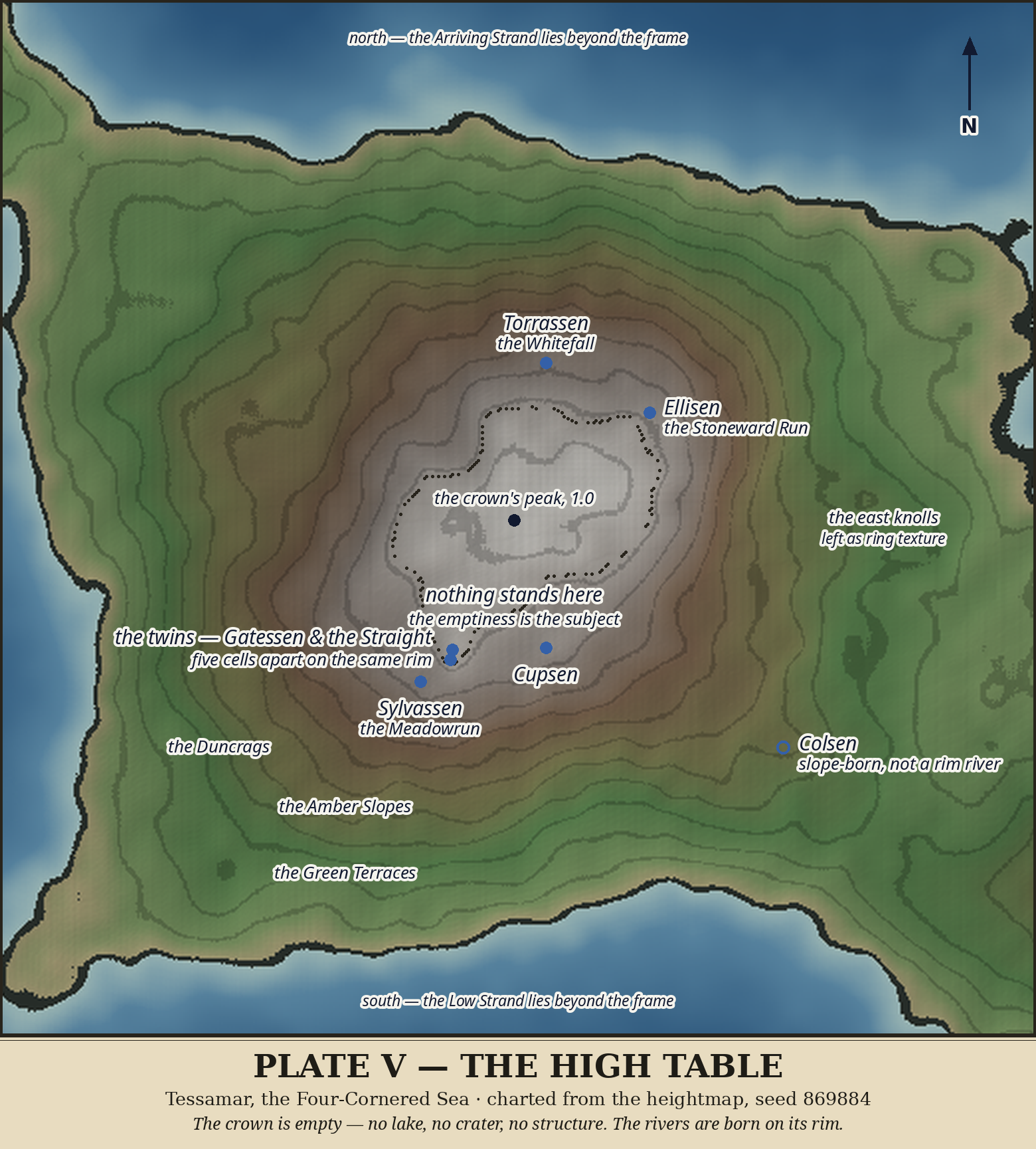
Every atlas has a place it circles and circles without landing, and this is Tessamar's: the centre of the world, the top of the Table, the place every river runs away from.
The crown is real, and it is broad — a gentle dome of the highest ground in the world, its peak a single marked point and nothing more. Inside the dotted line on the chart, nothing stands: no lake, no crater, no structure, no second summit, no field, no ruin. The chart says it in so many words — nothing stands here; the emptiness is the subject. The crown wears no separate name, either: the High Table already names it, and its top is not a separate place. A place can be empty without being unimportant.
The emptiness has a rim, and the rim has rivers — seven heads marked in river blue around the crown, because a centre is best described by what leaves it. The four quarters: the Whitefall off the northwest rim, the Stoneward Run off the northeast, Gatewater off the southeast, the Meadowrun off the southwest. The southern twins: the Straight, born five cells from Gatewater's head on the same high rim, the two labelled together, as twins — one turning down the Stair, one running due south without a bend. Cupsen, on the high rim just below the crown's edge, the bay's own thread. And Colsen, marked with an open circle, because it is not a rim river at all — it rises on the eastern slopes, in the col country between the Table and Savrel, well below the rim, and the open circle is the chart refusing to flatter it.
The rings are written where they read cleanest, on the southern side: the Duncrags, the Amber Slopes, the Green Terraces — the full stair of the world stepping down from the crown to the coasts. The small knolls that break the rings on the eastern terraces are texture, not places; a knoll is not a place until there is a reason to call it one. And so the centre stands as it is: the whole island charted from edge to edge, and its middle empty, and both of those true at once.
Plate VI — Savrel & the Southeast
The quiet corner
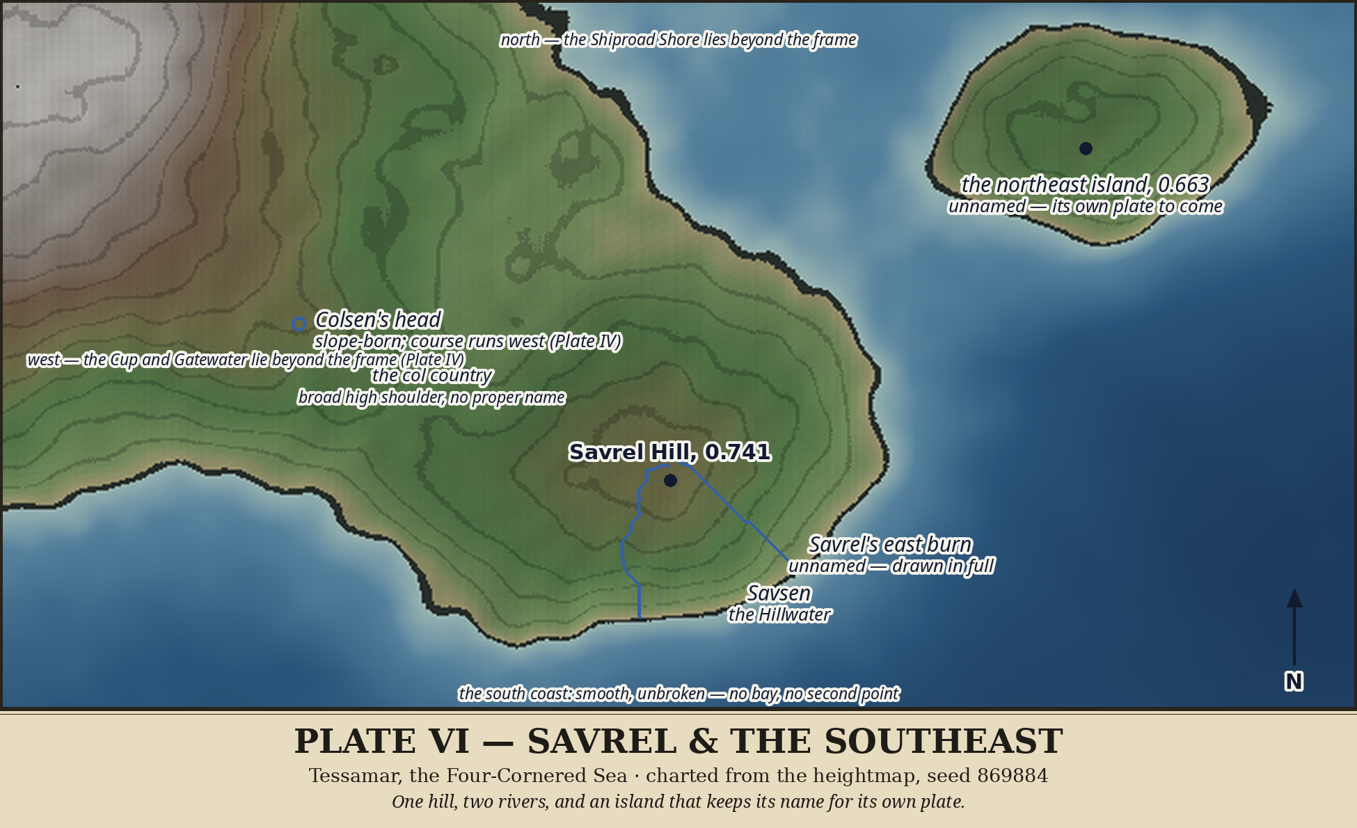
The southeast is the quiet corner of the charted world: Savrel itself, the ground that joins it to the Table, and smooth shore running down to a curve and a silence.
Savrel Hill is one height and no more: a single broad green dome whose cap is a table that never quite happened — hundreds of nearly level cells, Amber-Slope height, steepest to the southeast where it falls to the sea. There is no second summit on it, no knoll, no companion peak waiting for a name. A hill that is one height gets one name, and Savrel has it.
Between Savrel and the Table lies the col country — a broad high shoulder, not a notch, standing well above the sea at its lowest. Where Ostrel hangs by a thread, Savrel is joined at any honest tide. The shoulder wears no proper name: naming broad, unnotched ground would invent a feature that is not there. Colsen rises in this same high ground, slope-born, on its way to the Cup.
Savrel has two rivers, and both are born on its summit — a thing Ostrel cannot say, and the Table's rim rivers cannot either. Savsen, the Hillwater, rises on the cap itself and runs straight down the south face to the sea; a hill that makes its own river is not a failed table, but a smaller mountain with its own weather. The second, an east burn, runs from the summit cap down to a mouth on the south coast east of Savrel's point — drawn in full on the chart, and unnamed. It keeps its course and waits for a reason better than the fact that it exists: if it ever waters something, or carries boats, or cuts a valley worth a name, it will be named then, and gladly. Until then, two rivers leave one hill and only one of them is named, and that asymmetry is honest.
Below Savrel, the south coast runs smooth and unbroken — no bay, no second point, nothing invented to fill it. The Cup and Gatewater's mouth lie west of this country, and the fan is not re-told here. And at the frame's northeast, across open water, stands a great dome of an island, drawn whole — the subject of the next plate.
Plate VII — The Northeast Island
The island with no name
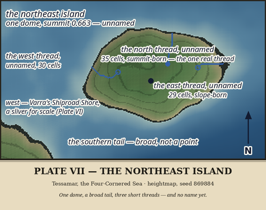
Across the Deepgate from Varra, and north of Savrel's sea, stands an island that is one thing only: a single rounded dome, elongated east–west, widest near its middle and tapering to a broad southern tail, its summit a flat-topped cluster with no second height anywhere on it. Its coast runs smooth and unbroken all round — no bay, no inlet, no point worth a cross, nothing for a boat to aim at or hide in. All around it lies honest open water; it stands alone in its own sea, apart, and its apartness is its whole character.
The dome carries three threads of water, and they are drawn in full, because a chart that hides water it found would be lying. The north thread is the island's one real water, born just below the summit cap and running almost due north off the dome's slope — the dome's main drain. The east and west threads are shorter, born on the slopes. All three wear no names. The north thread is shorter than Savrel's east burn, which itself wears none — and a shorter thread does not clear a higher bar.
And the island itself stays unnamed, even here, on its own plate, where a name would be easiest to give. No bay, no landing, no use, no legend, no second feature to distinguish it from any other dome in the sea. A name is not a label for a shape; it is a claim that someone, sometime, had a reason to call a place something — and this island has given no one a reason yet. Its broad southern tail points toward Varra like a question nobody has asked. If a boat ever lands on that tail, or a story ever attaches to the dome, or its north thread ever waters something worth a name, the island will be named then, and gladly. Until then it keeps its silence, and the silence is charted: whole, drawn, and unnamed.
Plate VIII — The Stepping Stones
Barely land at all
A stepping stone is a thing you walk on. These are barely land at all.
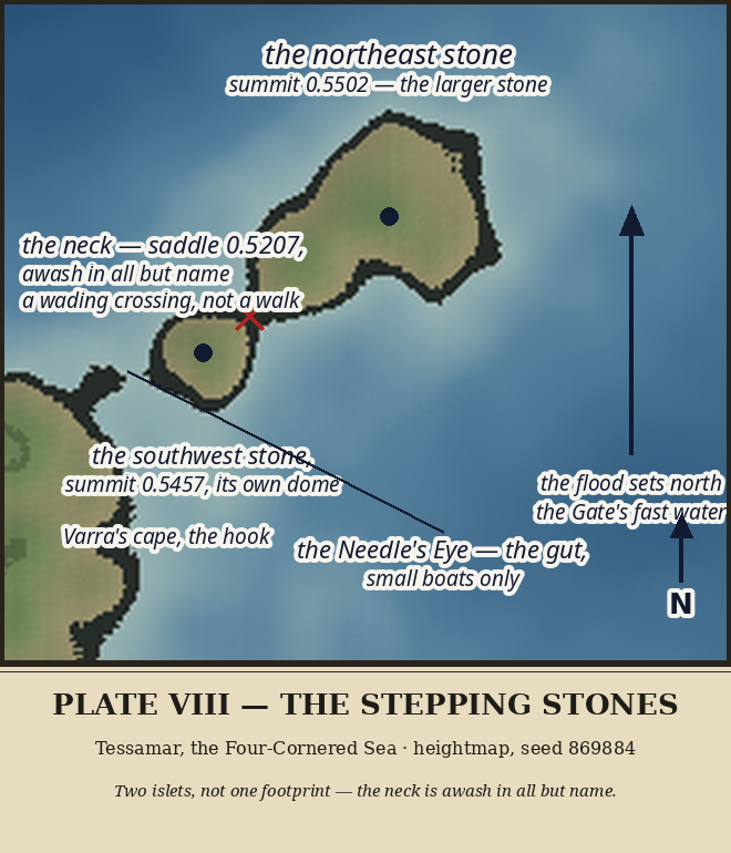
The Stepping Stones stand at the Deepgate's northern narrows, in its fastest water, like a footprint mid-stride: two islets on a southwest–northeast line, the larger to the northeast, each a broad, low dome with its own summit, the whole country standing barely above the sea in a wide shallow apron. Varra's cape and its small hooked point stand off to the southwest, like the other foot of the stride.
Between the two stones runs a neck — and the neck is the Stones' whole story. It sits a breath above the sea: at the chart's own level the two stones read as one footprint, but in any honest tide, surge, or slightly higher sea, they are two islets, and a walker crossing between them would be wading. The chart marks the neck in red and says it plainly, because a chart that hides a wading is a danger to someone: awash in all but name — a wading crossing, not a walk. The neck wears no proper name. A neck that is barely land gets a description, not an entry in the inventory; a sailor may one day name the wading, and until then the chart says what it is, which is enough.
What the Stones face is the water, and the water is fast: the Gate's flood arrows north past them, not merely through the channel south of them. To the southwest, between the smaller stone and Varra's hooked cape, runs the gut called the Needle's Eye — the closest approach in the country, the door's narrowest hinge, small boats only. A boat that threads it is choosing the Gate's quickest water at its tightest point, and the chart does not pretend otherwise.
The Stones stand alone in their own water — not an outrider of the island across the Gate, not a stepping-off point from Varra, but the door itself, standing in the current. They have kept their sailor's name since the strait was first charted, and no closer look has earned them another. The named doorstep to the Gate is barely land at all, and saying so plainly is this plate's whole work.
How this world was charted — the surveys, the seasons, and the decisions, kept as they happened — is recorded in The Charting.