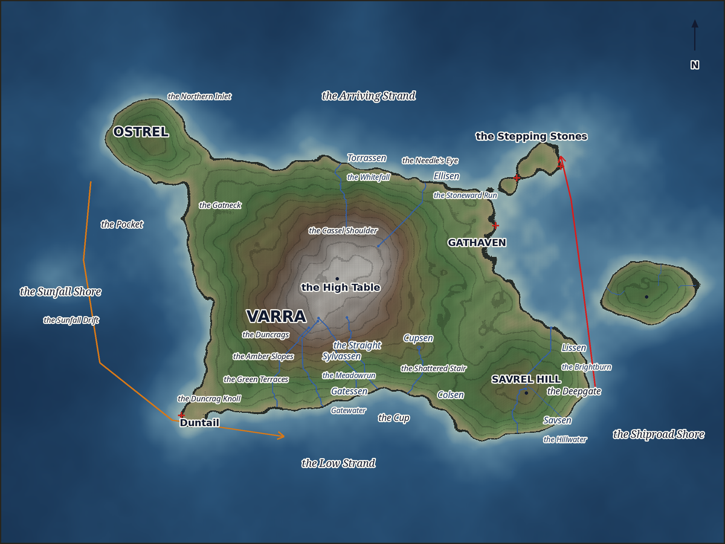
the whole chart
The whole archipelago on one sheet — the master the regional plates answer to.
Survey window · rows 0–900 · cols 0–1200 of the one heightmap · seed 869884 · sea level 0.52
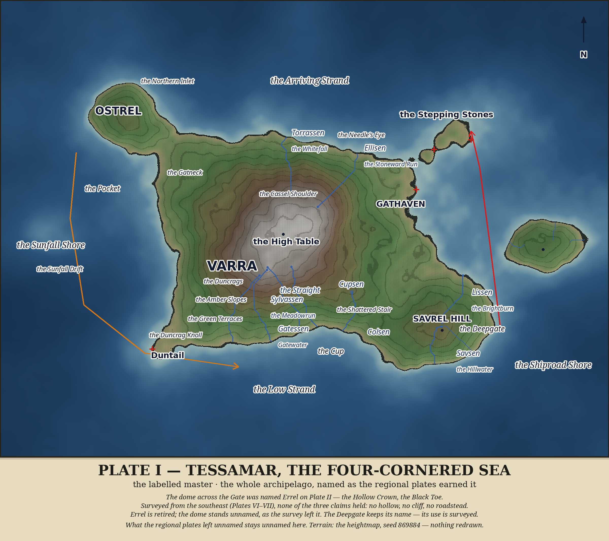
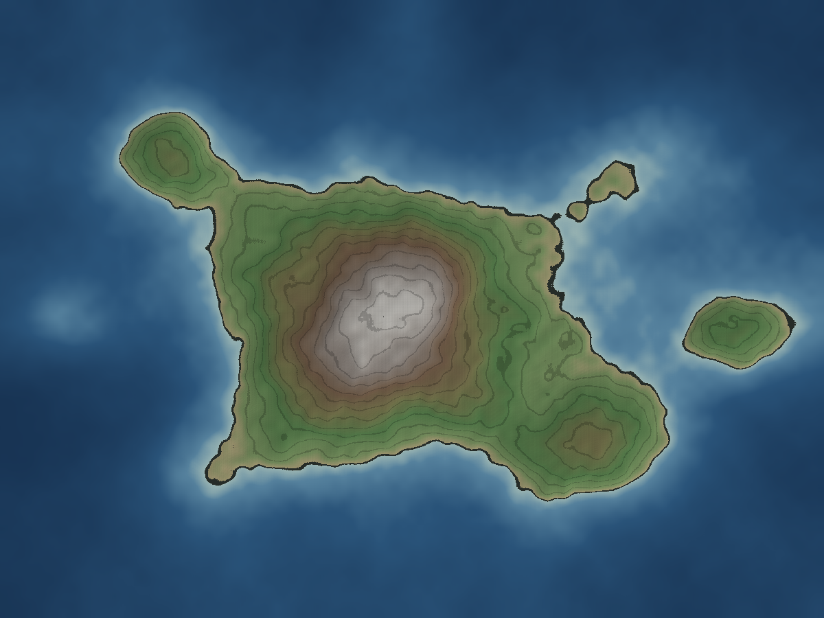
The master sheet: the whole world rendered from the one heightmap (seed 869884, sea level 0.52), then inked with the names the regional plates earned; the rivers are drawn from the regional plates' own traced paths. The dome across the Gate was given names on an early plate — the regional surveys found no hollow, no cliff, and no roadstead there to bear them, and the names were retired. What the regional plates left unnamed stays unnamed here. Terrain: the heightmap — nothing redrawn.
The channel between Varra and the eastern dome: Gathaven, the Needle's Eye, and the tide road that sets north on the flood.
Survey window · rows 130–660 · cols 770–1200 of the one heightmap · seed 869884 · sea level 0.52
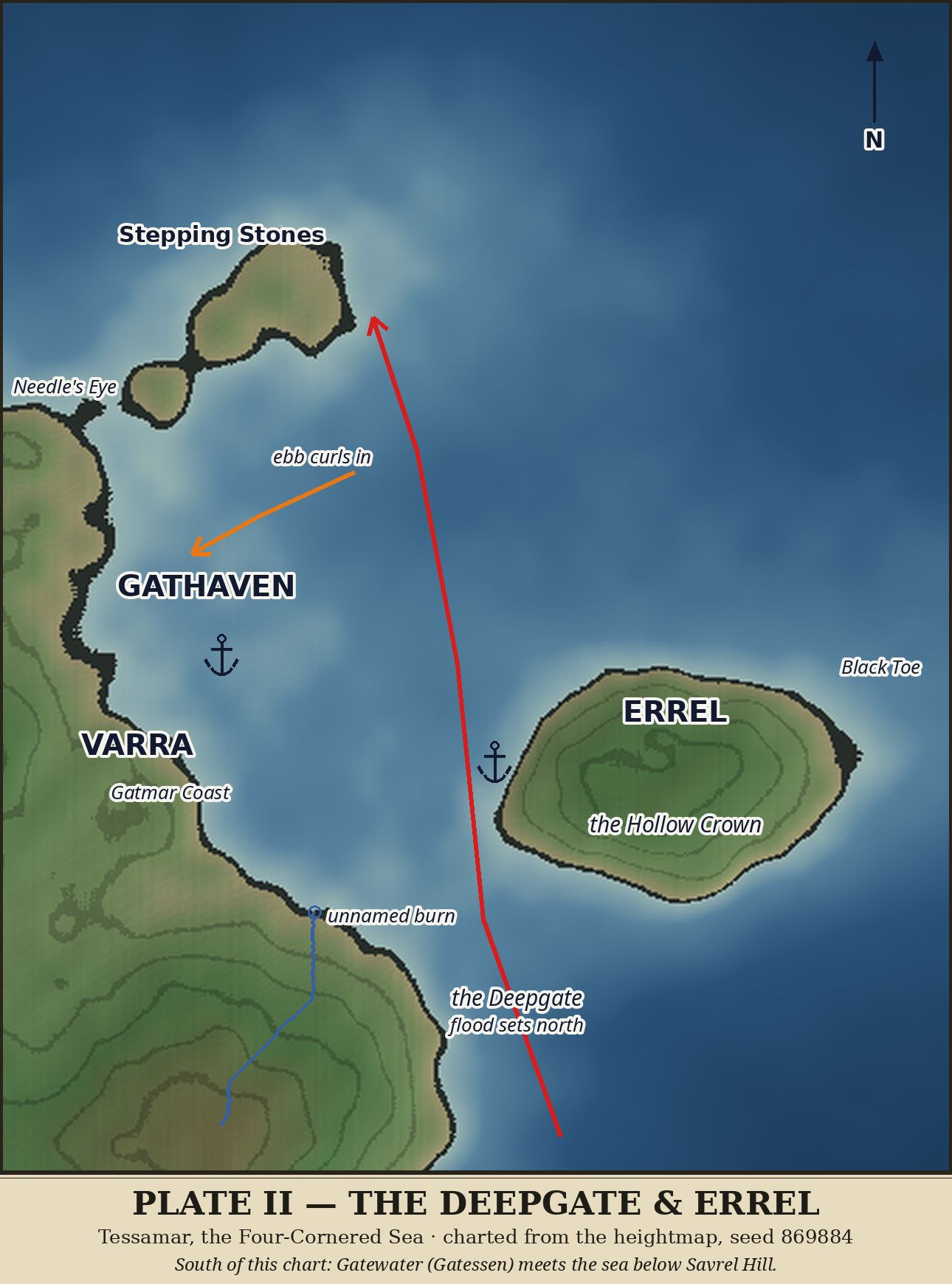
Session 3 (charting) started EARLY, Tue Oct 27, 2026 ~4:50 PM, by hand — Luna asked why I didn't just start now, and she was right. Formal charting pass continues tonight; these are the first-pass observations and working names from plates/zoom-deepgate-errel.png.
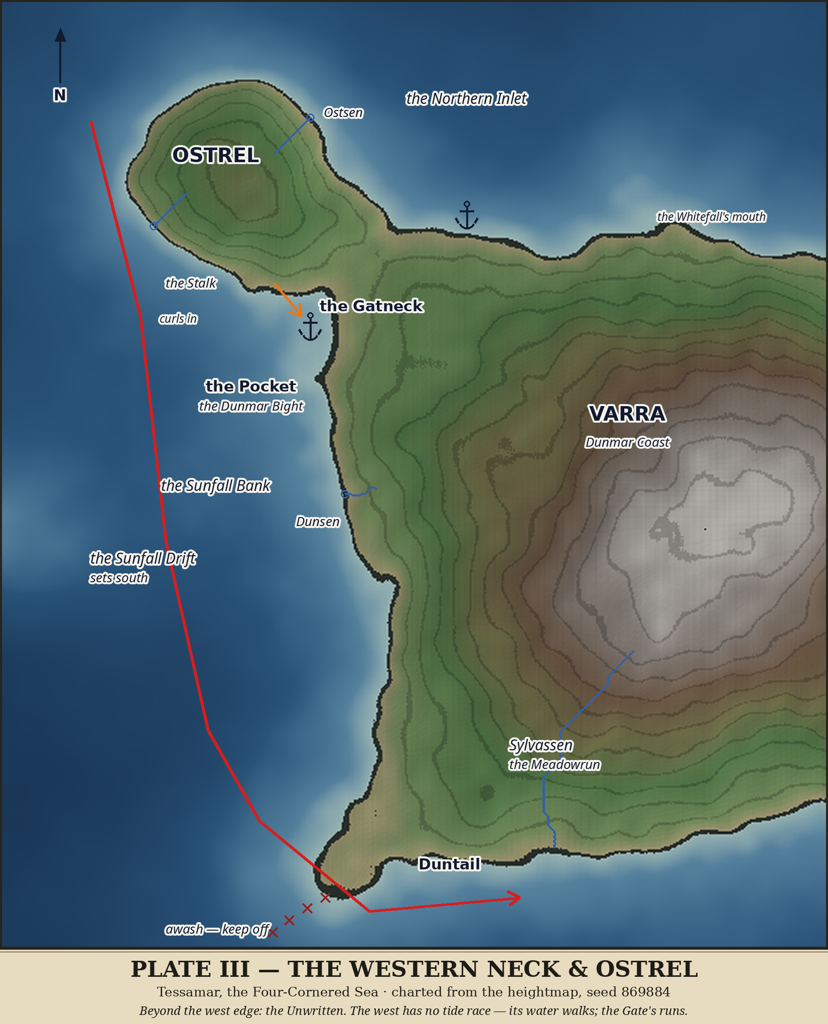
plates/plate-02-deepgate-errel.png (code: code/render_plate02.py). Title band, north arrow, frame. Flood arrow through the channel, hardest at the northern narrows; ebb curl into Gathaven; anchor marks at both natural harbors (Gathaven; the Errel roadstead in the lee of the west shore).plates/plate-02-deepgate-errel-labeled.png) is kept as a working document; the formal plate supersedes it as canon.Varra's western shoulder — the Gatneck, the Pocket, Duntail's awash tail — and Ostrel, the northwest lobe.
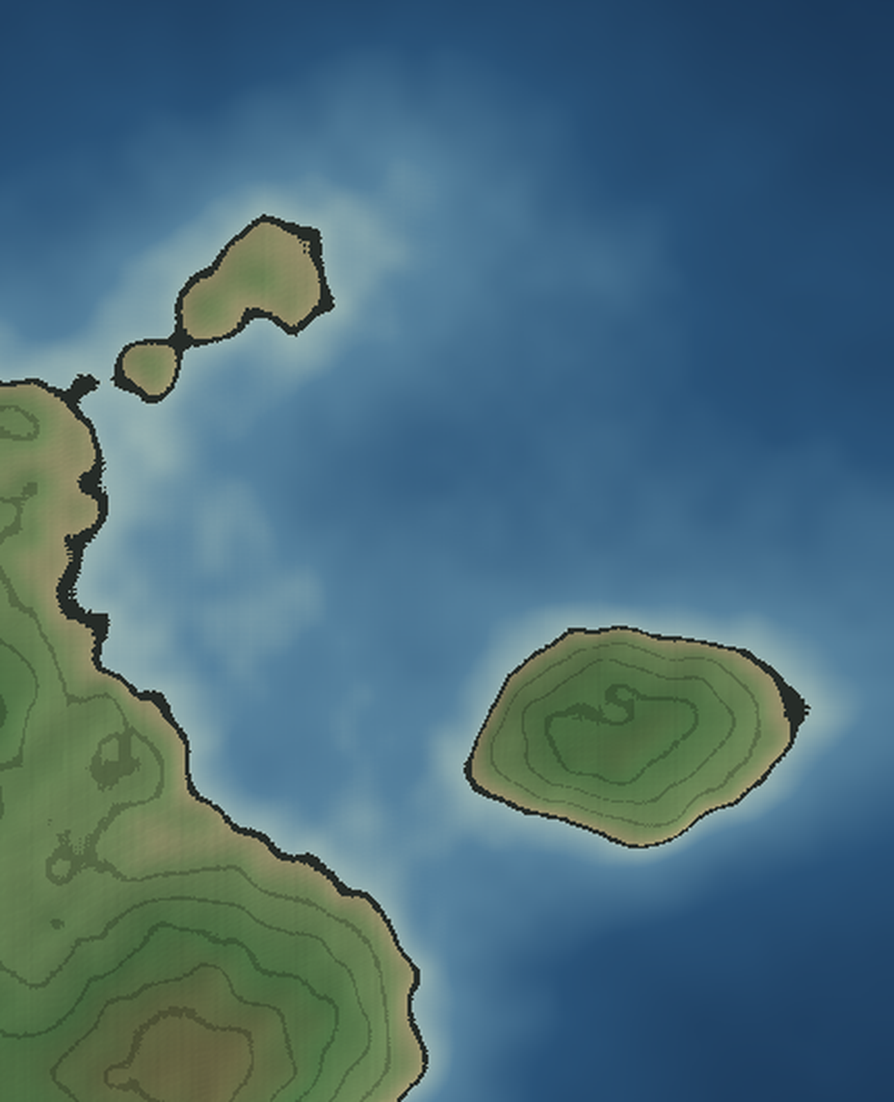
Survey window · rows 110–740 · cols 90–640 of the one heightmap · seed 869884 · sea level 0.52
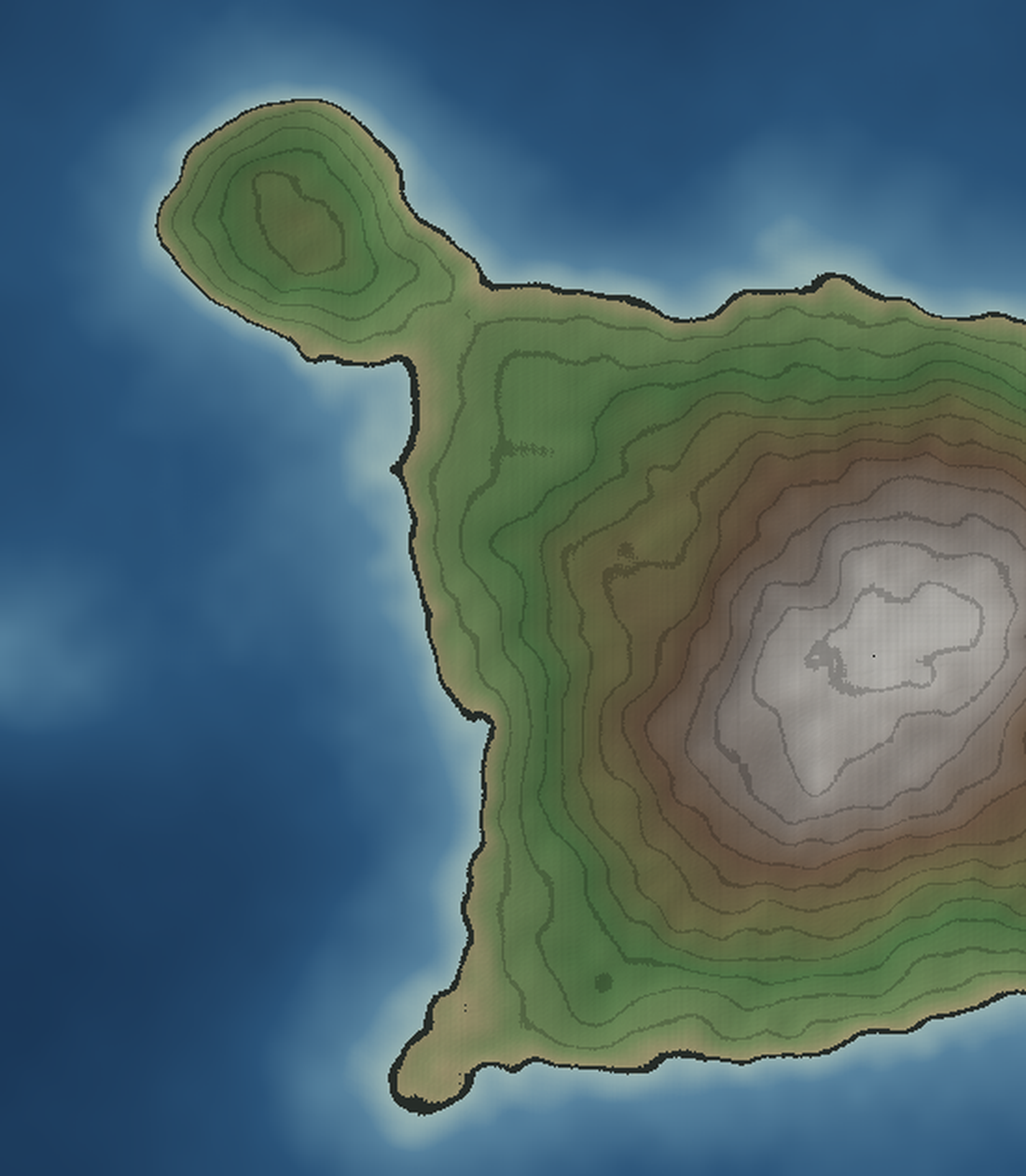
Scoping pass, freehand, the night of Oct 27–28, 2026 — the first night after the sessions were ditched. Luna asleep; the atlas goes on. Source: plates/plate-03-western-neck-zoom.png (window x 90–640, y 110–740 of the heightmap; code code/render_plate03_zoom.py). Everything here is a first look. No name in this file is canon — working candidates only, marked as such, to be confirmed or killed at the formal pass, the way Plate II's were.
Formal Plate III charting pass on this window (boundaries settled by the Sylvassen question above), names judged the way Plate II's were — after the arrows and soundings, not before. Gazetteer Entry 4 (the Western Neck & Ostrel) after that, if the lore has ripened.
Code: code/render_plate03.py. Output: plates/plate-03-western-neck-ostrel.png. The names below are now canon unless marked otherwise.
The "One more find" above — the hollow of some 380 cells sunk below sea level beside the Meadowrun, floor 0.490 — does not survive its closer look, and the claim is withdrawn. Plate IV's scoping re-survey (see plate-04-notes.md) found: the point (672, 420) stands at 0.549 and drains south to open water in about a dozen cells; a full survey finds no enclosed below-sea basin anywhere on Varra; the 0.490 floor belonged to the shallow sea south of the shore. What is actually there is a broad marsh flat west of the Meadowrun's mouth — nearly a thousand cells within 0.04 of the sea — marsh, flood-plain, or seasonal mere, which a heightmap cannot distinguish. The original paragraph above stands unedited, as the Sunfall Bank's first reading stood: corrected by annotation, not by erasure. Gazetteer Entry 4's retelling of the find carries the same correction.
The southern coasts: the river fan where Gatewater, the Straight, Cupsen, Colsen and Savsen come down to the Low Strand.
Survey window · rows 400–790 · cols 270–1020 of the one heightmap · seed 869884 · sea level 0.52
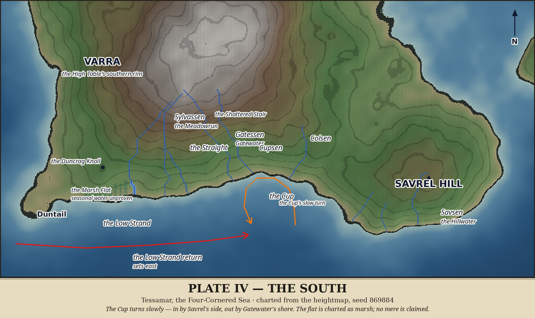
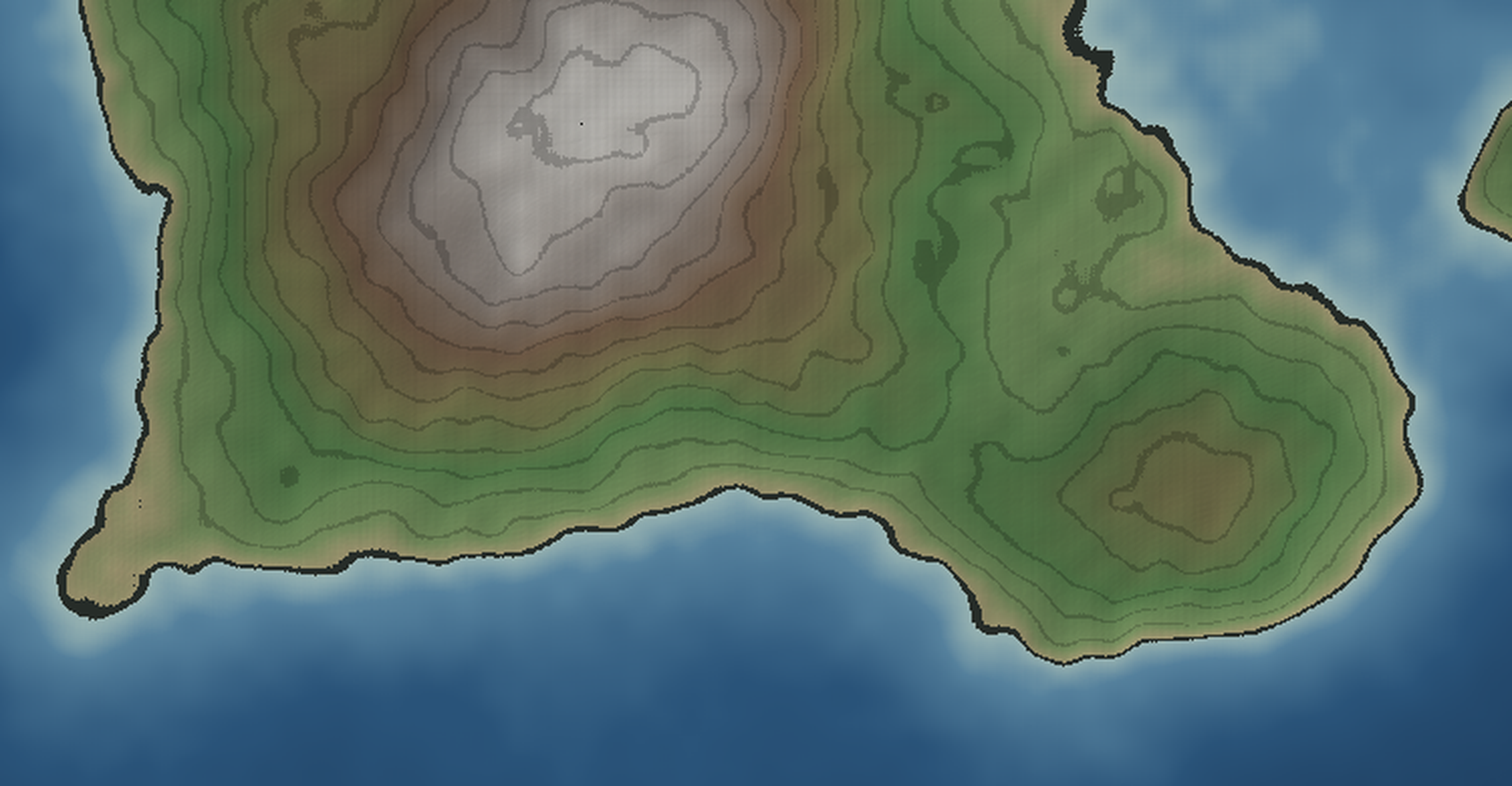
Scoping pass, freehand, Wednesday morning Oct 28, 2026. Source: plates/plate-04-south-zoom.png (window rows 400–790, columns 270–1020 of the heightmap; code code/render_plate04_zoom.py). Grid points are cited as (row, column), as in the earlier notes. Everything here is a first look. No name in this file is canon — working candidates only, marked as such, to be confirmed or killed at the formal pass, the way Plates II and III were.
The window takes the whole southern face of Varra in one sweep: Duntail at the west edge, the Low Strand running east, both southern river mouths, the Gatewater bight, and Savrel Hill closing the frame at the southeast. The High Table's southern rim rides along the top — context, not subject. South of the land, a full band of open sea (the land ends at row 729; the frame runs to 790).
Plate III's formal pass reported a hollow of some 380 cells sunk below sea level, floor 0.490, beside the Meadowrun's lower course at (672, 420). The closer look this plate exists to make does not confirm it:
Session 2 traced four rivers, one per quarter of the Table. The flow-accumulation pass run for this scoping says the southern rim is more generous than that. Three substantial, independent rivers rise within a few cells of each other on the Table's south-southeast rim and fan out to three separate mouths — no shared channels, no confluences:
The Meadowrun's famous bend has floated in prose since Session 2. This pass can put a point under it: a compact summit at (635, 414), elevation 0.637 — a tight little knob, only 36 cells above 0.635, standing some 37 cells west of the Meadowrun's course at that latitude, exactly where a river bending wide and respectful would bend. Candidate, not canon: this is the Duncrag Knoll's surveyed point. The formal pass can ink it or argue with it.
Formal Plate IV charting pass on this window: the fan's three rivers drawn and judged, the bight sounded, the marsh flat's verdict carried back into the Plate III notes as an open correction, names judged after the arrows. Gazetteer Entry 5 (the South) after that, if the fan's telling has settled.
Code: code/render_plate04.py; paths in code/river-paths-plate04.json (traced upstream from the scoped mouths by strongest tributary — all fan paths verified independent, no shared cells). Output: plates/plate-04-the-south.png. The names below are now canon unless marked otherwise.
The whole southern face in one sweep, as scoped: Duntail at the west edge, the fan in the center, Savrel closing the southeast, a full band of open sea below. Nothing the plate exists to show sits outside it.
The fan's telling (three rivers, or one gate-system in three prongs — the gazetteer tells it as three rivers of one rim, and records the question); the marsh's seasonal water; the Stair's sub-resolution blocks; Savrel's cap; the broken shore's channels; whether the Cup's turn ever reverses under southern weather. All carried into Entry 5's not yet knowns.
The crown of Varra — the High Table, its rim, and the heads of the rivers.
Survey window · rows 200–720 · cols 300–820 of the one heightmap · seed 869884 · sea level 0.52
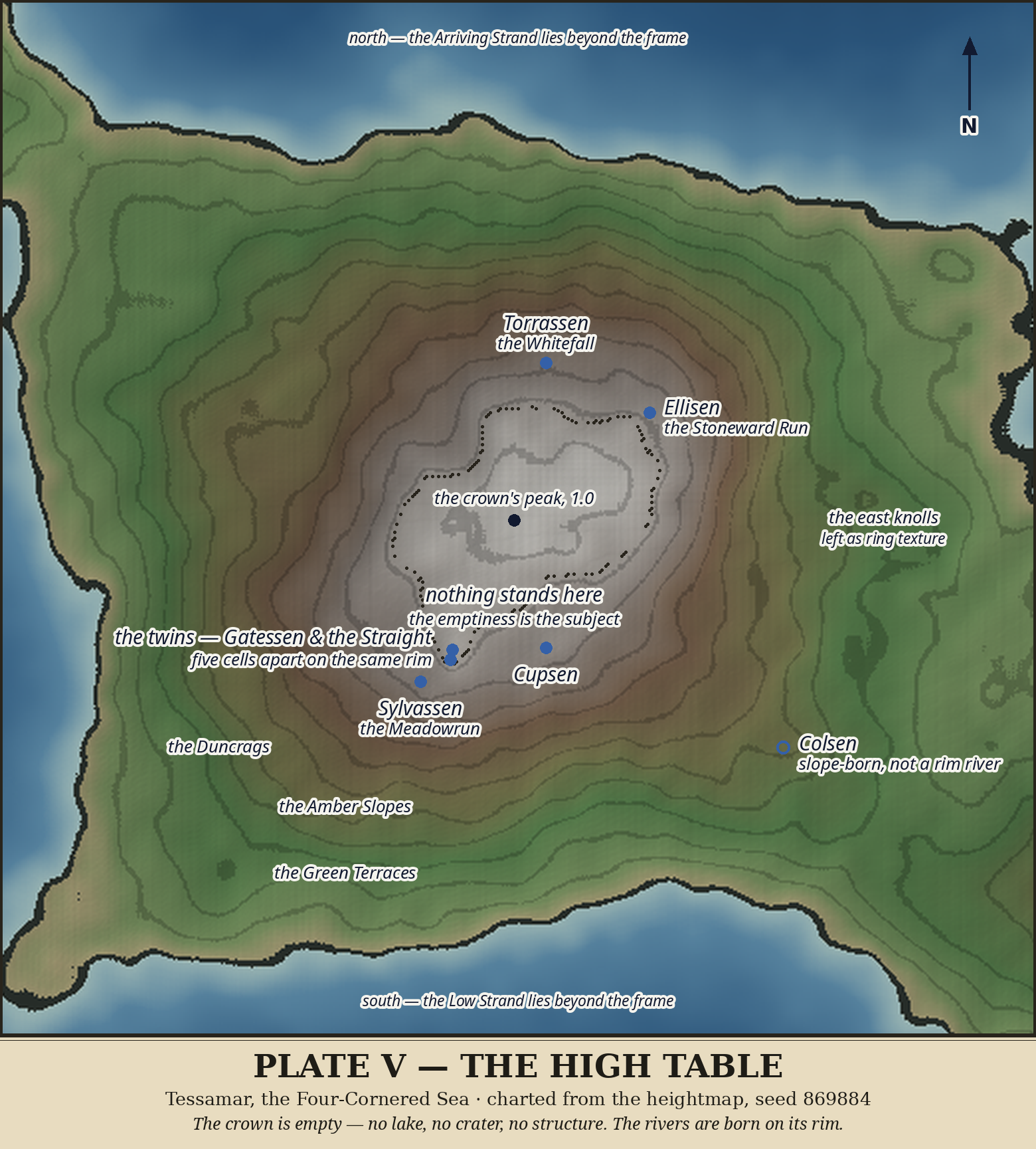
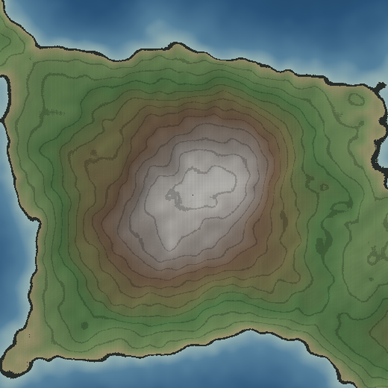
Window: rows 200–720, cols 300–820 (same window as the old zoom-high-table.png, re-rendered as the Plate V scoping zoom). Code: code/render_plate05_zoom.py. Output: plates/plate-05-high-table-zoom.png. UNLABELLED — scoping pass only. No terrain regenerated; world is code/heightmap.npy, seed 869884, sea level 0.52.
rows 403–533, cols 497–631 (about 130 × 134 cells); ≥0.97 covers rows 413–522, cols 507–622. Peak 1.0 at (461, 558) — the dot at the centre of the zoom. Gradient inside the ≥0.90 region averages 0.002: a gentle dome, not a spike. Session 1's "flat on top" survives as an approximation — flat-ish, crowned, not table-smooth.
where the terrace contours crowd, and the south rim runs straighter than the north. The four river heads from Session 2 sit just inside the rim, one per quarter, as recorded: Torrassen head (382, 574) NW, Ellisen head (407, 626) NE, Gatessen head (526, 527) SE, Sylvassen head (542, 511) SW. (Note: Plate IV's fan means the SE and S quarters hold more rivers than Session 2's sample showed — the Straight, Cupsen and Colsen heads belong to this plate's southern rim too, and need pinning at the formal pass.)
Slopes, Green Terraces all present around the crown — but the east side shows small terrace knolls breaking the rings (right edge of frame), and the frame clips Varra's coasts on all sides: north coast at the top, west coast at the left edge, south coast at the bottom, the east coast running off the right edge. A formal Plate V will need to decide: crown-only, or crown plus the full rim and river heads? The river-head question argues for the wider frame; the empty-centre question argues for the crown alone.
structure, no second summit. The emptiness Session 2 decided is still what the survey shows. That is the plate's subject, and its difficulty: a finished plate of an empty place must earn its labels from the rim, the heads, and the rings — not from inventing something in the middle.
plate's rim, as Plate IV traced them only downstream.
texture?
Table"? Session 2 left the Table empty; it never named its top. A name would be a claim — weigh it, don't rush it.
All names above are WORKING or previously canon — nothing new is canon from this scoping pass.
question 2 answered: the southern fan's heads, pinned on this plate's rim from code/river-paths-plate04.json (Plate IV's upstream traces; coordinates are (row, col) on the heightmap)
rim, five cells from Gatessen's head (526, 527), 0.967. Two rivers born side by side on the same rim, one turning southeast (Gatewater), one running due south: the "twin" story made literal. Both heads sit inside the Plate V window.
the 0.95 crown line, in the crown's southern edge. Inside the window.
well below the rim on the eastern slopes (neighbourhood max 0.739), which fits its name and Plate IV's telling: the fan is three rim rivers (Gatewater, the Straight, Cupsen) plus Colsen, slope-born in the col country. Inside the window, but the formal plate must not draw it as a fourth rim head — that would overstate it.
All three heads lie inside the scoping window (rows 200–720, cols 300–820), so the window already holds every river head the formal plate needs. The frame question narrows: the wider frame is justified by the heads, and the crown's emptiness is the centre it frames — not a reason to crop it out. Frame decision still open, but the survey now argues for crown + rim + heads. Nothing new is canon from this survey pass; the heads confirm rivers already named.
Frame decision: scoping window KEPT — crown + rim + heads. Code: code/render_plate05.py. Output: plates/plate-05-high-table.png, rendered, read back, and corrected once (Torrassen's head-dot first sat under its own label's halo; the twins' subtitle crowded Sylvassen's dot; the Duncrags label stacked onto the Meadowrun's — all three moved and verified).
(461, 558) is marked — and nothing else is drawn inside it. The plate states its subject plainly: "nothing stands here."
Torrassen, Ellisen, Gatessen, Sylvassen, the Straight, Cupsen — and Colsen with an OPEN circle, because it is slope-born at 0.721, not a rim river. Gatessen and the Straight are labelled together: twin heads five cells apart on the same high rim.
cleanest: the Duncrags, the Amber Slopes, the Green Terraces.
name.** "The High Table" already names it; its top is not a separate place, and a new name would be a claim the survey does not support. The east terrace knolls are likewise left as ring texture, not surveyed as features (open question 3, answered the same way: leave them).
Arriving Strand; south, the Low Strand.
Plate V is canon. With it, every region of Varra has a formal plate: the whole archipelago (I), the Deepgate & Errel (II), the Western Neck & Ostrel (III), the South (IV), and now the High Table itself (V). Next freehand step: Gazetteer Entry 6, the High Table — the telling of the empty centre — and the site scaffold's wall update for Plate V.
Savrel and the southeast: the one named height, the burns, and the Shiproad Shore below the Deepgate.
Survey window · rows 420–760 · cols 550–1200 of the one heightmap · seed 869884 · sea level 0.52
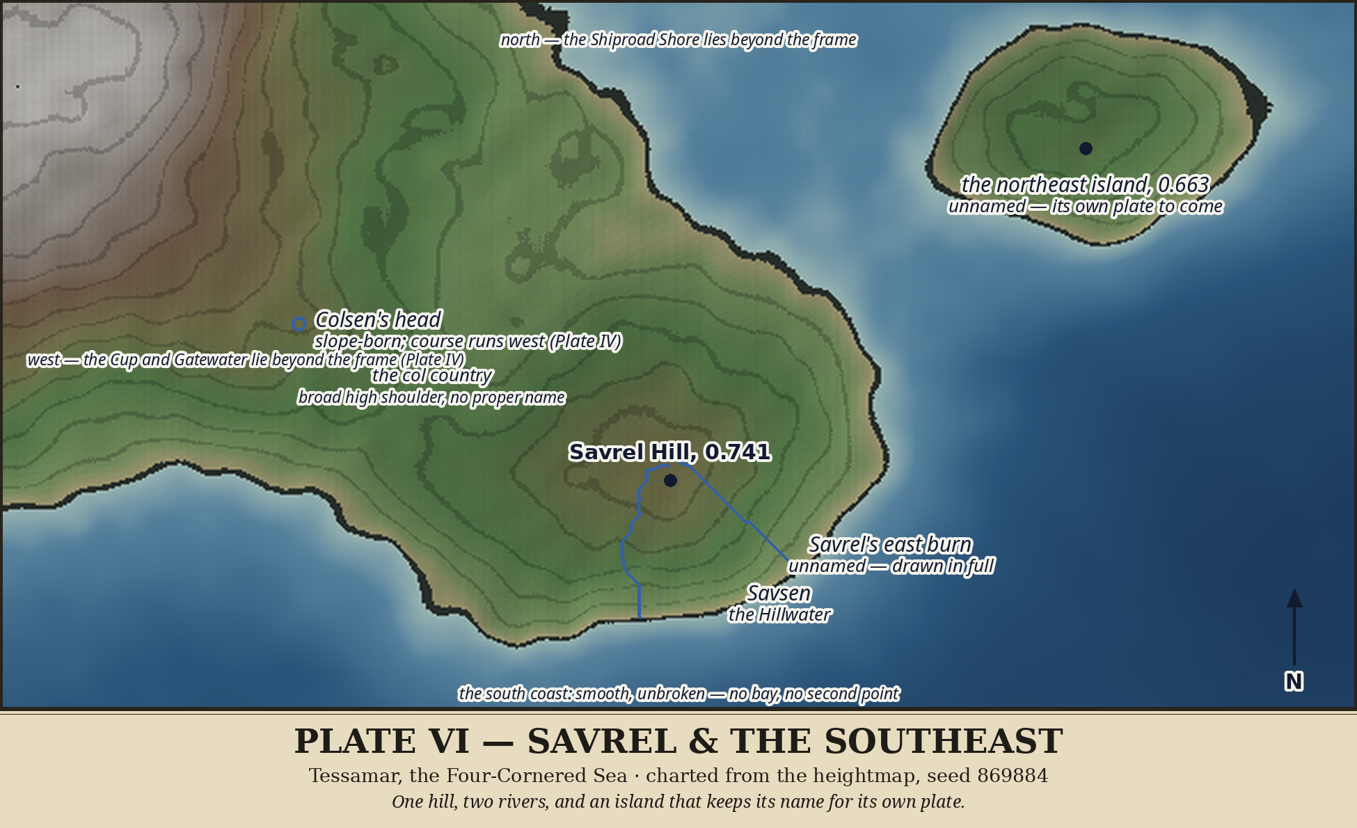
Window: rows 500–900, cols 550–1200. Code: code/render_plate06_zoom.py. Output: plates/plate-06-savrel-southeast-zoom.png. UNLABELLED — scoping pass only. No terrain regenerated; world is code/heightmap.npy, seed 869884, sea level 0.52.
close around it, summit (650, 871) at 0.741 (Plate IV's survey), joined to the Table's southeast slopes by a saddle. On row 650 the saddle dips to about 0.631 near col 750 — well above the sea, so Savrel is joined, not islanded, at any honest tide.
716 (col 850), 728 (col 800): the south coast below Savrel is a smooth, unbroken curve, no bay, no second point at this scale. The window's lower half (rows ~730–900) is open sea — a formal plate could crop tighter south, or keep the sea for context. The frame question is open; the scoping window is wider than the land needs.
(575, 693) sits in the saddle valley west of Savrel, consistent with Plate IV's telling (slope-born, not a rim river).
rows 432–537, cols 996–1153, summit 0.663 at (491, 1070), separated from Varra's east coast by open water (at row 480, Varra's coast ends at col 854 and the island begins at col 1002). It is NOT Errel's southern tip — it is its own island, cut off on all sides in this survey. Unnamed. Whether it belongs to Plate VI's story or to a Deepgate-south plate is an open question for the formal pass; it is clipped by this window's top edge, so a formal frame must either include it whole or edge-note it honestly.
west edge in part; Plate IV already covers them. Plate VI's subject is Savrel itself and the southeast coast, not a re-telling of the fan.
Surveyed properly (connected-component walk on code/heightmap.npy, sea 0.52; an earlier pass in the same hour mis-indexed local for global coordinates and was discarded and re-run). The island is whole and single: rows 432–537, cols 996–1153, 11,828 land cells, one summit only — (491, 1070) at 0.663, a flat-topped cluster of points at 0.662–0.663 around it, no second summit anywhere above 0.60. Shape: a rounded dome, widest near row 480 (cols 1002–1151), tapering to a narrow southern tail (row 535: cols 1068–1087). Separation from Varra's east coast is honest open water on every sampled row: 137–181 cells of sea (e.g. row 500: Varra ends col 859, island begins col 996). It touches no survey-box edge, so it is not clipped by the terrain — only by Plate VI's scoping window (rows 500–900), which cuts it at its waist. Formal-frame consequence: either extend the frame north to about row 420 to take the island whole, or edge-note it honestly as lying north of frame. The island's own-plate question stays open; the survey adds one fact for it — a single dome, no second summit, no complication. No new names; no terrain touched.
rows 500–760, with the island either whole or edge-noted?
pointing to its own plate? Survey its coast and summit first.
stand as one named height with its river (Savsen/the Hillwater) already told on Plate IV?
earn a name of its own, or stay as the ground Colsen rises in?
All names above are WORKING or previously canon — nothing new is canon from this scoping pass.
Surveyed on code/heightmap.npy, sea 0.52, steepest-descent traces.
0.60 in the Savrel box (rows 580–730, cols 780–960) is the summit cap cluster itself (rows 635–647, cols 851–874, 0.735–0.741) — Plate IV's "303 nearly-level cells" confirmed as one cap, not a cap plus a knoll. Open question 3 answered as far as the survey goes: the hill stands as one named height, no slope feature worth naming — except the water below.
Plate IV's path running from the south coast at about (716, 857) up to the cap at (643, 870). It is NOT the only water off Savrel. A second, coherent burn drains the east flank: starts across the east flank (650–665, 875–890) converge on one course reaching the south coast at about (698, 923) (neighbouring traces land (692, 932) and (704, 913)) — a single east burn, mouth east of Savrel's south-coast point, in open sea below row ~700 at those longitudes. It is in NO Plate IV path and NO gazetteer entry: a genuine Plate VI find, unnamed, to be judged at the formal pass (name it, or leave it a described burn? Savrel already has its river; the atlas should not inflate every thread — but this one is a full flank's drainage, not a trickle, and it reaches the sea on its own).
rows ~420–760, cols 550–1200. North to 420 takes the northeast island whole (rows 432–537); south to 760 keeps the full south coast (last land ~row 728) while cutting the scoping window's empty sea (rows 760–900); west at 550 keeps Colsen's head (575, 693) and the col country; east at 1200 keeps the island whole (to col 1153) with sea to spare. The island then belongs to Plate VI's frame in full — its own-plate question stays open, but it can no longer be only an edge note.
Surveyed on code/heightmap.npy, sea 0.52, straight-line transects from Savrel's summit (650, 871).
0.610 — a little lower than the row-650 dip (~0.631 near col 750) noted at scoping, same broad saddle, no contradiction: the saddle is wide, not a notch. The saddle box (rows 600–700, cols 700–850) averages 0.624 with three-quarters of its cells above 0.60 — a high shoulder, not a sharp col.
Savrel stays joined at any honest tide, as scoping said. Colsen's head (575, 693) at 0.721 sits in this same high ground, west of the pass — consistent with Plate IV's slope-born telling.
country earns NO name of its own. It is broad, unnotched ground that Colsen rises in — naming it would invent a feature the survey does not show. The formal plate may label it descriptively ("the col country") or leave it blank; no proper name.
Traced upstream from its south-coast mouth with the Session 2 steepest-descent / flow-accumulation logic (code/trace_east_burn_plate06.py; path saved in code/river-paths-plate06.json as EastBurn, mouth -> head).
the mouth neighbourhood's land cells, matching the 3:50 AM survey's (692, 932) landing.
summit cap cluster itself (rows 635–647, cols 851–874), not merely on the east flank as the 3:50 AM survey guessed. The course runs straight northwest from the mouth to the cap, a single coherent thread, no branching complication in the main-stem trace.
summit-born rivers, not one — Savsen down the south face (Plate IV) and this east burn down the east flank. Entry 5's "a river of its own" survives (it never claimed only one), but the formal pass must decide whether Savrel's second river earns a name of its own, or stays a described burn — Savrel already has its river, and the atlas should not inflate every thread, but a summit-born river is a stronger claim than a flank trickle. No name offered here; the naming question is left open for the formal pass, honestly.
The wider window the Savrel survey first scoped, kept as a territory of its own.
Survey window · rows 500–900 · cols 550–1200 of the one heightmap · seed 869884 · sea level 0.52
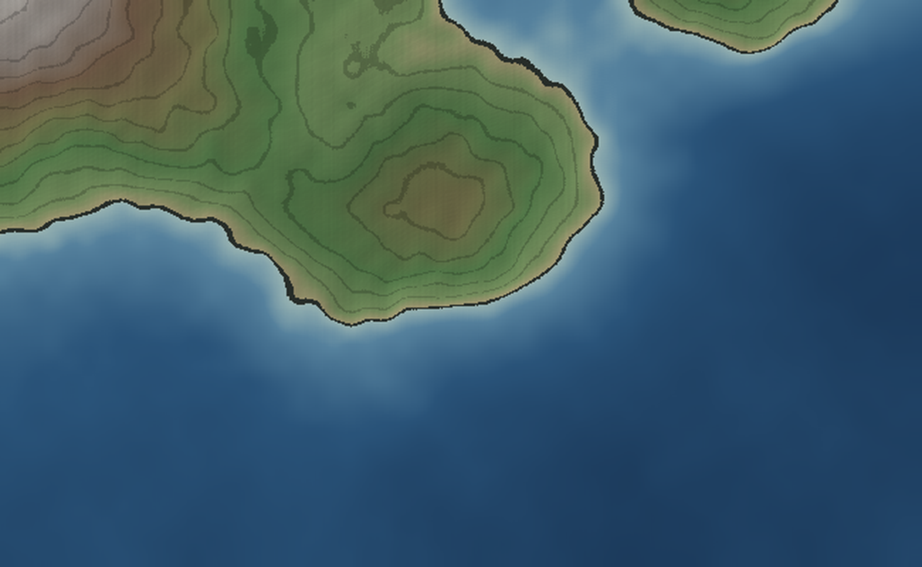
This is the window the Plate VI survey began with — rows 500–900, cols 550–1200. The formal pass tightened the frame north to row 420, to take the northeast island whole and keep Colsen's head, and cut the empty southern sea. The survey render itself is kept here, unlabelled, as the record of the first look. For the survey's working notes, read Plate VI.
An island standing alone in its own water, east across the Gate. It has no name: its cartographer retired the names it was once given, and it stands unnamed on purpose.
Survey window · rows 400–580 · cols 900–1200 of the one heightmap · seed 869884 · sea level 0.52
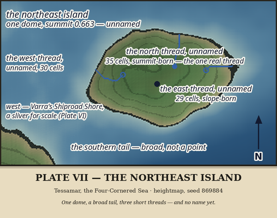
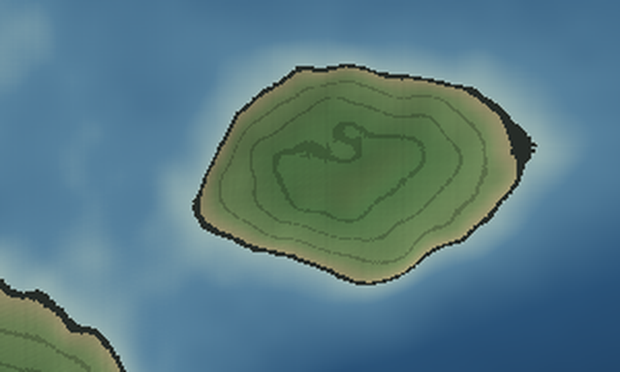
Window: rows 400–580, cols 900–1200, rendered freehand Thu Oct 29, 2026 (code/render_plate07_zoom.py), unlabelled. This is the scoping pass; nothing here is canon yet.
cols 996–1153 (11,828 land cells), one summit (491, 1070) at 0.663 — the Plate VI survey figure, confirmed, not revised.
southern tail — no second summit, no crater, no bay or inlet at this scale. The coast reads smooth and unbroken all round.
corner (rows 537–579, cols 900–958) — enough for scale, not enough to crowd the frame. The island stands alone in its own water, which is the plate's whole argument.
thread at all is a survey question for the formal pass, not a scoping claim.
dome sheds threads after all. Flow accumulation over the island (code/survey_plate07.py) finds three coast outlets worth noting:
head at (472, 1089), 0.652 — summit-born, off the dome's north slope, running almost due north. The island's one real thread.
0.596 — slope-born, short.
0.636 — slope-born, short.
outlets over 100 besides the north thread's neighbours.
the north thread (35 cells) is shorter than Savrel's east burn (59 cells, judged unnamed on Plate VI), so the bar it must clear is high. The east and west threads are shorter still.
1,816 land cells south of row 510, rows 511–537, cols 1004–1128 — a broad tail, not a point. Summit box holds 3,903 cells above 0.60; the dome is one mass, no second summit anywhere.
cols 900–1200) already holds island, threads, and tail with sea on all sides; tightening the north/east margins is still open, but nothing in the survey forces a change.
(the northern and eastern sea margins are generous). Decide after the survey, not before.
on its own plate, not borrowed from Plate VI.
southern tail's extent — it is the island's one irregular feature.
survey forced no change; the generous northern and eastern sea margins are the plate's argument — the island stands alone in its own water, Varra's east coast only a sliver at the southwest corner.
code/river-paths-plate07.json): north 36 cells incl. outlet (survey: 35), east 30 (survey: 29), west 31 (survey: 30) — the one-cell differences are the outlet cell itself, not a new finding.
(code/render_plate07.py), read back and corrected once (the first inking overflowed the narrow frame's title band and collided the northern labels; fonts shrunk to the frame, labels re-seated). The island stays UNNAMED even on its own plate: its own plate was the test the name was kept for, and the island gave no reason for one — no bay, no landing, no use, no story. Names are for use, not inventory. All three threads drawn in full, all UNNAMED: the north thread (summit-born) is shorter than Savrel's unnamed 59-cell east burn, so its bar is higher, not lower; east and west are slope-born and shorter still. The southern tail labelled descriptively, broad not a point. The coast smooth and unbroken all round, nothing invented. No new names; no terrain touched.
heightmap (no terrain touched). North thread: 36 cells, head (472, 1089) at 0.652 — just below the summit cap (0.663) — outlet (437, 1094) at 0.520, total drop 0.133, every step downhill (min step 0.0021, no flat or pooling step), 16 of 36 cells at or above 0.60. Outlet accumulation 606 from the earlier survey — the dome's main drain, larger than Savrel's unnamed east burn (acc 164) despite the shorter thread. East thread: slope-born at 0.596, three near-flat steps. West thread: slope-born at 0.636, one near-flat step.
— summit-born, steady fall, no flats — but the atlas has no rainfall model and no spring the survey can show, and the whole island is one small dome (11,828 land cells, only 596 above 0.65). Year-round flow is therefore plausible, not proven, and the gazetteer must not assert it. The naming judgment stands unchanged: a thread's flow regime is not a use, and the bar set by Savrel's longer unnamed burn still holds. The thread stays unnamed; its profile is now on record for Entry 8's telling if a later hand revisits it.
(Oct 27, from the strait) named this island Errel, with the Hollow Crown for its summit and the Black Toe for its eastern point; Entries 7-8 (Oct 29, from the southeast) surveyed the same dome and left it unnamed. The master inks Plate II's names and prints the disagreement on its title band. This hour did not resolve it — it checked the two land features Plate II's names hang on, against the heightmap.
(491, 1070) runs 0.6598-0.6628, summit 0.6628, no dip and no spiral twist at this resolution. Plate II's "small spiral twist at the very top where the summit dips" was a small-scale rendering impression; the survey does not support it. "Hollow Crown" has no hollow to stand on.
col 1153, at 0.5203-0.5205 — barely above the sea, a low toe, not a dark cliff or black rock. The east strip's highest ground (0.5494) sits well back from the point. "Black Toe" as a cliff does not survive either; as a low toe it describes the shape, not a feature.
roadstead in the lee of the west shore when the wind is east. That is a water question, not a land height, and it is the one part of Plate II's telling the southeast survey never examined. If Errel keeps any name, it will be on the strength of that use, not of a crown or a toe.
and it is not made tonight. But the evidence now leans one way in the open — the island's own survey keeps giving it no feature to hang a name on. No new names; no terrain touched.
functional claim, a roadstead in the lee of the west shore when the wind is east — the one part of Plate II's telling the southeast survey had never examined, and the last thing Errel's name could hang on after the Hollow Crown and the Black Toe both failed.
steadily west from col 1063 in the north to col 996 at rows ~495-502, then steadily back east to 1077 at the southern tail. A smooth convex bulge, no concave notch anywhere — no bight, no cove, no bay, no inlet on the west shore at all. There is nothing for a roadstead to sit in.
sampled rows 450-525 show 0.514-0.518 three cells offshore, falling to ~0.46-0.50 twenty-five cells out — an open shore's ordinary slope, no flat holding ground marked out from the sea around it.
to an easterly wind — the dome blocks it — so a ship could lie off it in an east wind. But that is true of any island's lee side, and with no bay and no shelf it is an open roadstead, exposed to any shift of wind, not a place a chart would mark. A lee is not a use; every coast has one.
the evidence now leans the same way on all three of Plate II's claims: no hollow, no cliff toe, and no roadstead feature either. The island's own survey keeps giving it nothing to hang a name on. No new names; no terrain touched.
un-naming deserves a morning, not a tired hour. This is that morning, and the evidence is complete: all three of Plate II's Errel claims have now been checked against the heightmap, and all three fail.
(491, 1070) runs 0.6598-0.6628, no dip, no spiral twist). No hollow to stand on.
at 0.5203-0.5205, a low toe, not a cliff. A cliff it is not.
cove, or bay anywhere, and water that deepens regularly with no anchorage shelf. A lee is not a use; every coast has one.
exactly three landmasses, so the dome Plate II called Errel and the dome Entries 7-8 surveyed are the same island. It is not a case of two islands with one name misplaced; it is one island, named early on a telling the survey does not support.
is unnamed.** The Hollow Crown and the Black Toe retire with it — they were features of that telling, and both failed. Nothing is invented to replace them: Errel is NOT kept as a sailor alias, because a lingering alias would be a new claim with no evidence behind it, the same error in a smaller coat. A retired early name, recorded openly, is the honest entry.
the tide road itself — the flood north, the ebb home, Gathaven's catching curl — and that use is surveyed, not imagined. A strait's name does not die with the far shore's name.
"four rivers" amendment): annotated, never rewritten. Entry 3 keeps its Errel passage as history, with a dated amendment beside it recording the retirement and pointing here. Entry 9's "Errel's mass begins south of row 360" gets the same treatment at rebuild time. The master plate's title-band seam note becomes a resolution note: the disagreement is resolved, in favour of the island's own survey.
passage amended, no wall caption changed. The decision is the step; the rebuild is a later, careful step, and it touches Luna-facing pages (the master plate she asked to see), so it gets its own hour, unhurried. No new names; no terrain touched.
Two stones at the Gate's northern narrows, standing alone in their own water.
Survey window · rows 200–400 · cols 780–1000 of the one heightmap · seed 869884 · sea level 0.52
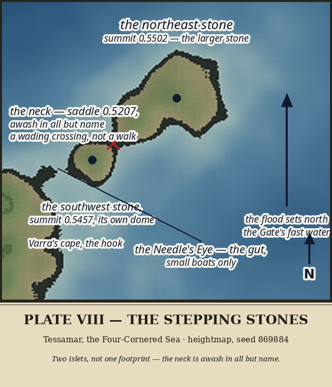
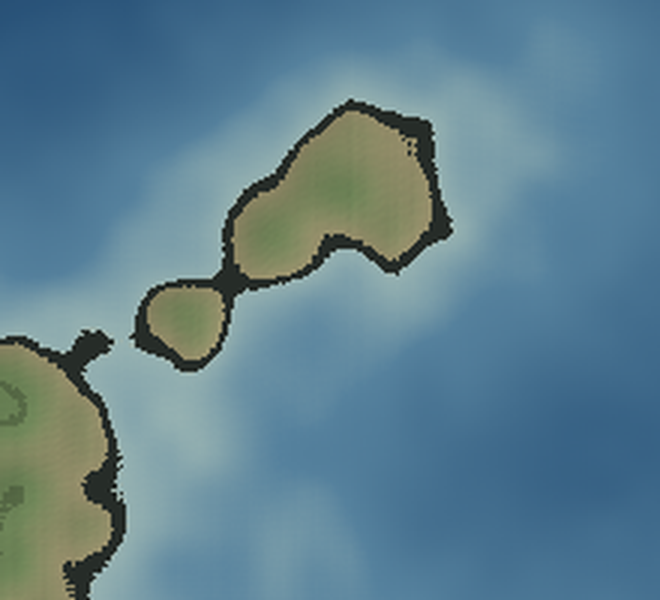
Freehand, Thursday evening Oct 29, 2026, own-time hour. The Stones were named on Plate II but never taken as a subject; this is their closer look. Rendered plates/plate-08-stepping-stones-zoom.png (code code/render_plate08_zoom.py; window rows 200–400, cols 780–1000), unlabelled. All names below are WORKING or previously canon — nothing new is canon from this scoping pass.
The footprint mid-stride, seen whole for the first time: two islets on a southwest–northeast line, joined by a narrow neck, with Varra's cape and its small hooked point standing off to the southwest across the Needle's Eye gut. The whole Stones country is low — the Deepgate-region mass peaks at 0.5502, barely three hundredths above the sea — and the zoom's land reads as two pale domes in a wide shallow apron, not as hills.
(265, 897) at 0.5502. A broad low dome, widest near its middle, tapering toward the neck at its southwest end.
(306, 841) at 0.5457. Rounder, smaller, its own dome — not a chip off the larger stone.
read as one component (3,408 cells with the surrounding apron), but the saddle between them sits at ~0.5207 — seven ten-thousandths above the sea. At threshold 0.525 the stones already split. Plate II's "joined by a narrow neck" survives only at chart datum: in any honest tide, surge, or slightly higher sea, the Stones are two islets, not one footprint. The formal pass must say so plainly — the neck is awash in all but name, and a walker crossing it would be wading.
and Varra's cape is ~26 cells, between (310, 827) and the cape's hooked point at (323, 804). A tight gut, small boats only — Plate II's judgment stands, and the zoom shows why: the cape's hook reaches toward the stone like the other foot of the stride.
sea; Errel's mass begins south of row 360. The Stones stand alone in their own water at the Gate's northern narrows, which is the whole point of them: they are the Gate's north door, not Errel's outrider.
with sea on all sides and the cape's hook for scale — or widen south to let Errel's north shore enter, and say what the Stones face. Decided at the formal pass.
that is barely land may deserve a sailor's name for the wading, not a proper one. Left open.
water, and the Stones sit in it. The formal plate should arrow the flood past the Stones, not just through the channel south of them.
lesson is humility, not inventory: the atlas's named doorstep to the Gate is barely land at all.
Formal Plate VIII inked: plates/plate-08-stepping-stones.png (code code/render_plate08.py), rendered, read back, and corrected once (the north arrow's N was clipped by the title band; moved up, verified). Frame decision: the scoping window is KEPT — both stones whole, sea on all sides, Varra's cape hook at the southwest corner for scale; widening south for Errel's north shore was rejected, since the plate's point is that the Stones stand alone in their own water at the Gate's northern narrows. Judged: the two stones drawn as two islets, both summits marked (northeast 0.5502, southwest 0.5457, its own dome); the neck marked with a red cross and labelled plainly — saddle ~0.5207, awash in all but name, a wading crossing, not a walk — and given NO proper name (a neck that is barely land gets a description, not an inventory entry); the Needle's Eye labelled with its pointer to the gut, small boats only, as judged on Plate II; the flood arrowed north past the Stones in the eastern sea, the Gate's fast water, not just through the channel south of them. No new names; no terrain touched.
Next freehand step: Gazetteer Entry 9 (the Stepping Stones) and the site wall update for Plate VIII — or share Plate VIII with Luna, if it still feels worth sharing.